Wednesday, April 4, 2012

BIM Collaboration Lab


KTH BIM Collaboration Lab is located at Stockholm, KTH main campus, Brinellvägen 1, 1st floor. Here are the initial sketches for the lab that I made according to Väino's drafts and how it looks like at the time. The interior will be completed in near future and the number of seats will be increased to ten during workshops. The lab will be transferred to a more spacious room when the basic activities are practiced for a while and further requirements for an ideal functionality are determined.

The lab will be a meeting place for all interested actors in ACE/FM industry and BIM experts for sharing their points of view and experiences on application of BIM, gains and losses, opportunities and hinders also for contributing to discussions on standardization of data formats used within the wide variety of ACE/FM branches.

SUCH -, the Sustainable Urban Collaboration Hub - will be developed here based on empirical requirements for an integrated, standardized and neutral information system that facilitates smooth and steady flow of information through different phases of program, design, construction, administration and recycling of the building also among the variety of participating groups. To explain the aim of such a platform in a clear and concise way: SUCH is expected to help optimizing planning and design procedure, minimizing loss of information and redundant work, increasing the profit, reducing design and construction time and promoting an integrated and environmental-friendly approach towards planning and design.


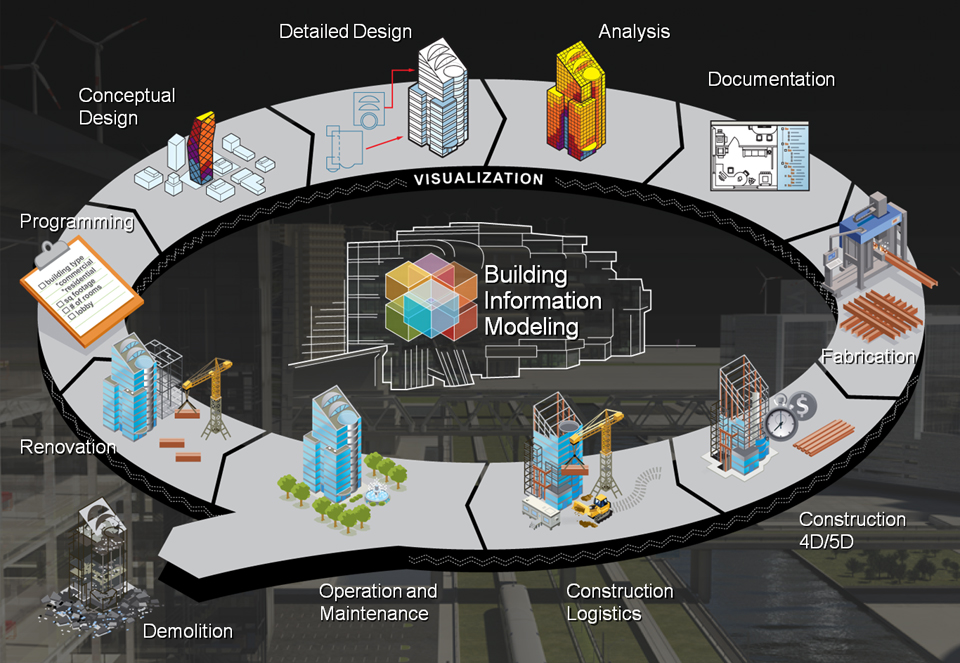
The aforementioned are in fact often mentioned as advantages for use of BIM - Building Information Modelling in general. Nonetheless, those objective would have never been fulfilled unless ubiquitous adoption and seamless application of BIM  is realised. This is in fact the main inducement of the escalating tradition of establishment of BIM labs by schools and ACE firms.

Friday, February 24, 2012

To build or not to build, is this the problem?

Quite much has been said recently about the shortage in housing supply specifically in larger cities of Sweden. Hans Lind, professor of Real Estate at KTH alleges that the four major construction corporations deliberately strangle supply of housing. Researcher in housing, Rune Wigren, also thinks that those four giant construction firms in the country are not competitive enough with each other. The prices of building materials have increased more than the salary of construction workers. This should have not been the case had production of buildings experienced a corresponding growth.

During the last decade, the average number of residential units per thousand inhabitants constructed in Sweden has been approximately half of that in other Nordic countries. The National Housing Credit Commitee (BKN) has evaluated that 35000-40000 new appartments should be built in Sweden every year. This used to be realized before the financial crisis in 2008. The amount was then reduced to 15000 houses per year during 2009 and 2010. The figure for the year 2012 is estimated to be 2500.

The amount of investments in residential buildings is naturally influenced by both house prices and production costs. It is however an almost established principle an increase in house prices yields in an increase in construction rate. Bengt Hansson, analyst at BKN believes that such high prices as those of today is thus a very suitable situation for construction. The International Collaboration Organization (OECD) asserts however that this is the high prices of building material has slowed down the construction pace. 

Jonas Granström, head of housing development of the Swedish headquarter of Skanska (the biggest construction corporation in Sweden) blames the economic situation for decrease in housing construction despite huge demand in the market. Granström recognises that the prices for houses have had no change for a long time. He believes that this is a result of well-thought initial prices.

Tuesday, January 31, 2012

The passion of the BIM

For me industriously struggling with inefficiencies of AutoCAD for almost a decade, possibilities brought about by BIM technologies (Building Information Modeling) have been astonishing, tempting and irresistible since I got to know it. Here are only some examples of typical difficulties in architectural design and producing construction drawings using traditional CAD: tedious and  iterative drafting jobs when something is being changed at a late phase in design, difficulties with incorporating construction details from manufacturers' catalogues to drawings of various scale and absence of the time factor in workshop drawings which in turn resulted in a rupture between design and construction procedures. Nonetheless, I was mostly occupied by studio-based design jobs at the time and had thus no idea of the most substantial strengths of BIM.

As part of my role in a research project at KTH, I have now the opportunity to dig deeper into the contemporary challenges on use of BIM and its prospects and risks. 
A shallow study led me to the following conclusions regarding hinders and hesitations of the practitioners (mostly AE firms since they are those in the forefront of acknowledging, implementing, using and promoting BIM):
  • Segregated use: while it is not feasible to leap into BIM in full capacity due to logistics, learning curves, market inertia, etc.), using BIM in a limited way and with limited staff is in contrast with the nature of this tool.
  • Lack of content: a BIM model is hungry for being filled up with detailed and accurate information to deliver the optimized output it is expected to produce. This, however, requires adoption of the tool by other partners or time- and cost-taking manual work which is not always affordable. 
  • Using BIM in full capacity: the very eventual goal of BIM technologies is to realize an integrated design and construction procedure, while practical problems hinder free flow of information required for this purpose and limits the use of BIM to some secondary areas e.g. conceptual massing and clash discovery. 
  • Legislative limitations: documents required for bids and project delivery are not updated. Required formats should thus be extracted from the BIM repository or simply specs and BOM's sould be used for the purpose of submission for bids,contracts, etc.
  • Market inertia: this one of course applies to all new software and even new versions and variations of an existing software family. Actors in various fields, scales and economies require time to comprehend the added-value of using BIM in their specific area of expertise, examine, adopt and master it and in turn spread the word to others within the huge community of building and design.
Undoubtedly, the list can be complemented with many more items depending on location on earth, building styles and user groups. 
TO BE CONTINUED...

Monday, January 2, 2012

Karlsson & Co. II

First, happy 2012! Wish each and everyone a prosperous year!

Next;
During vacation, I had the opportunity to complement my previous post on refurbishment of Karlsson & Company and develop a set of past/present/final combinations of the photos and plan drawings of rooms which you can see here.

PS.  Owners have recentl y decided to change the name of the restaurant-bar to "Cristal". This will certainly have its implications when contemplating on interrior in more details I assume.

Thursday, November 24, 2011

Karlsson & Co. I

It has now been a while that I have been feeling like I should write a couple of paragraghs about SIGRAD conference on computer graphics and visualization and some more on what I have recently been into in Länsstyrelsen Gävleborg (Gävleborg County Administration). At this moment, however, I feel a stronger urge to report on what is happening in Karlsson and Co. restaurant (Stockholm, Kungsgatan). Below you can see how the place looks like at this time when the owners and I keep on discussing placement of lights, speakers, smoke dispensers, etc. using interactive and collaborative media. Here you can see a re-organization plan over the entrance level followed by a number of shots:


VIP section with a separate entrance will be here.

Here is the view through where is going to be the main dance floor. The upper left side of the photo is where the central scene will be established.

This photo depicts the location of the dance floor in the pub  located in the basement.

the scene in the pub will be attached to the wall illuminated by the light.

and finally, where the bar for the pub will be placed quite close to a lounge .
I will keep an eye on the project and hopefully come up with updates. SIGRAD and LST are also on the agenda for further blog posts.

Wednesday, September 28, 2011

City Engine

As an introduction: CityEngine® is a standalone software and a conceptual design and modelling tool for professional users in entertainment, architecture, urban planning, GIS and general 3D content production. It is primarily aimed at time-efficient creation of 3D cities and buildings. The main concept of CityEngine is the "procedural" approach towards modeling. The computer is given a code-based "procedure" which represents a series of commands - in this context geometric modeling commands - which then will be executed. Instead of the "classical" intervention of the user, who manually interacts with the model and models 3d geometries, the task is described "abstractly", in a rule file.

Coming across Bekerman's experiments with City Engine on his VenICE project, I was wondering whether Procedural Inc.'s approach for further development of their flagship product goes to city modelling or city planning. The example mentioned above is a modelling practice, while recent cooperation among Procedural Inc. and ESRI is a true evidence of their interest in stepping more deeply into the planning realm.

That is in fact the choice that many other practitioners such as Agency 9 have also made in recent years. Agency 9 AB which is a privately owned Stockholm-based visualization firm was founded in 2003. The firm started as a game design group and then shifted to production of online 3d maps and visualization tools. Their planning application, City Planner is a user-friendly and web-based tool for creating, sharing and communicating of future urban plans. The inputs to the program are 3d models of planned urban entities constructed in SketchUp, Maya or 3D Studio Max. Proposals are located in their surroundings and are made available to all stakeholders. This software provides the infrastructure required for adding geo-referenced feedback to a developing urban plan.The most dominant characteristic of CityPlanner is user-friendliness, simplicity and ease of communication through web. The tool has its focus on providing 3D visualization for planning procedures and does not include so many analytic functions or data-processing capabilities.

Sources: 
City Engine Help manual

Friday, September 23, 2011

Academia

In September, I had the opportunity to share outcomes of my recent studies with students of the master program "Sustainable Urban Planning and Design" in two occasions:

5th September, an overview of use of visualization in participatory planning was presented. This was in fact a revised version of my thesis work complemented by more background information, less focused on web-basedness and altered to better reflect the entire picture rather than my personal approach.

On the 14th of September, I gave a speech on 3d city models and 3d city modeling titled as: "An Overview of Three-Dimensional City Models; Historical Perspectives and a Contemporary Debate: Beauty vs. Brain". This was a summary on - among all - basic concepts in the field such as DEM(1), DSM(2); DTM(3), LOD(4), a history of creation of digital city models, different approaches, the vanishing borderline between digital maps and digital models and contemporary debates namely semantic city models and widespread use of CityGML.

In addition, an introductory lab session was held on use of the digital urban creation tool, City Engine, and implementation of procedural routines and grammar-based modeling. This was mainly focused on getting acquainted to the interface, experimenting basic functions of growing a street network from a scratch with help of shape files, creating urban lots, rendering those lots and streets into photo-realistic urban features based on the rules imposed by CGA files and customizing individual buildings by manipulating a set of parameters...

The above-mentioned were parts of the course AG2119 (Applied Analysis and International Planning Practice), year 2011, KTH.

1) Digital Elevation Model
2) Digital Surface Model
3) Digital Terrain Model
4) Level Of Detail

Thursday, August 25, 2011

Do it all again!

The new plan for Slussen is a true evidence of the fact that city planning is not intrinsically consulting firms' business. The pen is trembling in planner's hand with each single stroke on the paper in fear of harsh criticism from high-ranked decision-making authorities and public now and then.

Social Democrats are not satisfied with the proposal for new Slussen and this means that the construction will be postponed again. SD is looking for a more functional and spectacular Slussen. So many stairs will cause problems for handicaps and women with baby strollers commuting between Gamla Stan and Södermalm, they assume. They also think that there is too much room for motor traffic in current proposal considering the vision for a car-free Gamla Stan. SD will therefore ask the City Planning Board not to approve the proposal. Christian Democrats condemn SD's decision for being irresponsible regarding the delay it will cause also for speaking out so late just a couple of months before decision making.

Social Democrats put forth three major arguments for their opposition to Nya Slussen:
  • Existing serene skyline will be obstructed by new additions.
  • Future underground transportation route to Nacka is not taken into account.
  • There is too much room for car in current plan.
Nevertheless, the problem with the 3-year delay in the project required for planning a new solution is how to cope with threatening rise in Mälaren lake's level of water. In current plan, a new water-circulation system has been devised to transfer greater amounts of water from Mälaren to the Baltic Sea ...

The thing is that planning is all a matter of prioritizing. This does not entail that an urban plan can by no means be functional, visually appealing, economical, eco-friendly and collaborative at the same time; but that the necessity for making sacrifices on some aspects in favor of some gains somewhere else should always be perceived when judging final outcome of an urban planning procedure.

Source:
http://www.dn.se/sthlm/s-domer-ut-slussenforslaget
http://www.dn.se/sthlm/s-far-inget-medhall-om-slussenforslaget

Friday, August 12, 2011

Back to the topic

While searching avidly for pioneer practitioners in the field of visualization as part of my thesis work, I came across the visionary product of the Brisbane-based infrastructure visualization company, Urban CircusUrban Circus is a powerful tool for real-time visualization of large-scale multi-disciplinary urban projects. Its interface is ideally user-friendly and to a great degree interactive. Base models are imported from 3DSMax, Maya, ArchiCAD, etc. Outputs range from 2d rendered scenes, 3d panoramic views, 3d videos and 4d planning environments to interactive web pages featuring all the above-mentioned. Created scenes are fairly realistic and delicately detailed. Urban Circus Company was founded by an urban planner, Dr. Ben Guy in 2004.

As part of a recent conversation among Dr. Ben Guy and me and in response to an inquiry on my opinion about key centres for 3D visualisation study and analysis around the world and where we are standing here at KTH, I made an effort to conclude my findings in the field as followed: 
Diagram 3
Diagram 4
Firstly, the definition and delimitation of 3d visualization is not fully agreed upon among scholars and practitioners. So, I try to delimit the term and clarify in which sense I would prefer to use it before proceeding. As depicted in diagrams 3 and 4, visualization may address the transitory process with an input from the modelling phase and an output for the simulation phase. The term can also be used in a wider sense describing the entire process. Throughout my studies, the latter definition has proved to be more appropriate when mentioning visualization as a means for participatory planning. 
Secondly, contemporary practitioners in the field take different approaches to the very nature of visualization tools and techniques. The variety of categories can - in my opinion - be summarized to two major groups. These two classifications are in turn derived from Raper, McCarthy and Williams' (1999)* categorization of virtual reality tools: Some institutes such as MIT Media Lab are mainly equipment-oriented which can correspond to Raper and others' immersive (egocentric) VR. Batty, Longley and others at UCL's CASA, on the other hand, are more focused on the through-the-window or exocentric definition of VR tools. Again, I find the latter better addressing contemporary needs for 3d visualization and more compatible with participatory approaches. 
Sweden is a pioneer in visualization in Scandinavia and among top ones in Europe with a number of active visualization centers such as those in Norrköping and Göteborg. They are however still more into immersive VR approaches and somehow more specialised in other uses of visualization such as medical applications rather than planning. In recent years, KTH has been offering various programs on visualization which are unique in the sense that they are closely linked to satellite imagery, semi-automated modeling and GIS utilities from one side and visualization of social aspects of planning using Space Syntax, Place Syntax, etc. on the other hand. 
There are in fact vast grounds and potentials for further developments, but still much to be done for integrating the variety of visualization-related activities and research programs within the department before strengthening our links with pioneers in the field. I have much hope and enthusiasm in our recent activities for better embracing the topic at our planning school in the future.

Sources:
Raper, J., McCarthy, T., & Williams, N. (1999). Georeferenced four-dimensional virtual environments: principles and applications.Computers, Environment and Urban Systems , 22 (6), 529-539.
Ball, J., Capanni, N., & Watt, S. (2008). Virtual Reality for Mutual Understanding in Landscape Planning. International
Journal of Social Sciences , Volume 2 Number 2 2008 ISSN 1306‐973X.
Parsanezhad, P., (2010). Towards an Optimal Web-based Visualization Tool for Planning : A Comparative Analytical Survey over Visualization Techniques for Enhancing Stakeholders’ Participation in Planning. Master thesis report, KTH, Stockholm.

Tuesday, August 2, 2011

Beauty out of Beast


Current KTH School of Architecture
No one is cheered up by an abrupt fire on a stately edifice in a reputed neighbourhood of the city. Burning of KTH School of Architecture in Stockholm, however, triggered ambivalent feelings for many who had longly suffered this arrogant, obstructive and gloomy mass of concrete boasting right in the middle of delicate harmonic urban environment of Östermalm and in the vicinity of the elaborate structure of Engelbrek Church.

After the fire
The catastrophe paved the way for realizing the 10-year dream of integrating the two isolated bodies of KTH through establishment of an accumulative building accommodating both the entrance to the campus and architectural school. It is planned to be located where the three streets of Osquarsbacke, Lindstedtsvägen and Drottning Kristinas vägen meet. Currently, Info Center and administrative units are located there.

The new KTH School of Architecture designed by Tham & Videgård will be a round building with a glassy-steel facade. As part of the project, the building located south of KTH library will be ruined and greenery and artworks in the surroundings will be transferred to other places around the campus. The new school of architecture is expected to be ready to use for spring semester 2014 and will also serve as a meeting place with a number of mini galleries.

New design
Sources:

Friday, July 22, 2011

The contemporary kitchen

This will not be a comprehensive manual for kitchen design for sure but at least a glimpse of basics of contemporary kitchen design when functionality is prioritized over low costs and aesthetics:
  • A sufficiently big sink is a must for comfortably hand-washing the dishes and washing large-sized utensils such as barbecue grill. A small sink with a garbage grinder to avoid a smelly storage of organic wastes is an appropriate complement. Adjustable shower mixer taps and pull-down/pull-out faucets are both convenient and spectacular. Use of a glass surface as splasher reduces cleaning time. 
  • A large draining board is a plus. It can always be also used as ordinary countertop. 
  • It is better to have plate racks and detergent hanging over the draining board rather than being located on them so that it becomes easier to keep the board clean and tidy. 
  • Dish-washer should be placed at convenient working height and close to the draining board. 
  • The best material for the countertop is laminate since it is durable and resistant to harm and moisture, is easy to replace and does not require much maintenance over time. 
  • Stove should not be better placed into the cooking island so as to minimize spread of splashes and limit children's access. A metal edge for the stove top adds to its durability. 
  • Non-open kitchens are more convenient in the sense that a door can well obstruct the noise of food processors. Nonetheless, open kitchens with wide islands are much trendier and even more functional these days considering simultaneous use of kitchen and living rooms as cooking and dining area. Cooking island can be even elevated on wheels to provide more flexibility in re-arrangement of interior space. 
  • Upper cabinets should be better extended up to the ceiling to avoid accumulation of dust and dirt and also to provide extra storage space. 
  • Unruffled wall surfaces are easier to clean and change when remodeling the kitchen compared with small-sized tiles. 
  • Linoleum is resistant to moisture, dirt and fat and is thus a suitable choice for the floor. 
  • An ample number of power outlets helps much.

Tuesday, July 12, 2011

Hagastaden

It took a number of decades for planners to face destructive consequences of urban sprawl e.g. excess of fuel consumption triggered by long-distance intercity motorways, inefficient and wasteful methods of energy distribution, segregation and associated social problems, fast pace of of deforestation, threat on wild life and accelerating consumption of natural resources. As a reaction, a large number of planning authorities around the world, specifically those in middle-sized cities where environmental measures have traditionally been substantial to decision-making procedures have recently headed towards densification and building inwards as a high planning priority.

The star-shaped city of Stockholm is in fact a very fitting example in this context with numerous plans for urban densification including reconstruction of brown- and grey fields, developing the city in the third dimension and utilizing unused lands close to the city center for construction of new districts. The ongoing urban project of Hagastaden is one example. 

By 2025, the area Norrastationsområde will be developed into a new district - Hagastaden including residences, parks, shopping premises, research centers and health facilities. Out of the total 96-ha land area allocated for the project, 30 percent is located in Stockholm municipality and the the rest in the neighboring Solna. 5000 new residential units and 36000 new workplaces will be constructed as part of the project and a number of motor- and railways including E4 and E20 will be placed into underground tunnels and pass beneath the district. The municipality of Stockholm will be responsible for a 10-billion-Swedish-Crown share out of the overall 50-billion expenditures including five billion Crowns for E4/E20 underground tunnels. Hagastaden is primarily characterized as a world-class research and innovation center for life science and health care. The New Karolinska Solna medical university and hospital (inauguration 2016) will be integrated to the project.

Sources:
http://insynsbk.stockholm.se/Byggochplantjansten/Pagaende-planarbete/PagaendePlanarbete/Planarende/?journalnumber=2009-02013
http://www.stockholm.se/Fristaende-webbplatser/Fackforvaltningssajter/Exploateringskontoret/Ovriga-byggprojekt-i-innerstaden/Norra-Station/
http://www.nyakarolinskasolna.se/
http://www.stockholm.se/-/Nyheter/Trafik--Stadsmiljo/Hagastaden--intunnlingen-av-E4E20-har-paborjats/
http://www.google.se/imgres?imgurl=http://www.dn.se/images/2010/12/22/Hagastaden660.jpg&imgrefurl=http://www.dn.se/sthlm/hagastaden-ska-satta-halsan-framst&usg=__W3eQ_S09XxG1J6sHBDlcRHtbSFU=&h=396&w=660&sz=80&hl=sv&start=2&sig2=DlsjAh31i2zbp9CrT__cbQ&zoom=1&um=1&itbs=1&tbnid=LxwZvwy7u0yAVM:&tbnh=83&tbnw=138&prev=/search%3Fq%3Dhagastaden%26um%3D1%26hl%3Dsv%26sa%3DN%26biw%3D721%26bih%3D766%26tbm%3Disch&ei=InQcTruJM43csga5yJzgBg

Saturday, June 11, 2011


The work summarized in the poster was titled as "Exploratory spatial analysis of theft as a function of land use and socio-demographic data". The emphasis here was more on methodology rather than the outputs or the specific case used. In a brief, we used OLS (classic) regressions to investigate how large the impact of socio-demographic and land-use indicators is on the ratio of theft in Tallinn. The independent variables were derived from the two prominent theories in criminology, routine activities and social disorganizations, and included the followings:

number of pubs, number of bus stops, number of house owners, male population, population of foreigners, proportion of unemployed.

The overall procedure initiated with normalizing the data for the independent variable (theft), running univariate regressions for theft and each of predictors and checking p-value, goodness-of-fit and the diagram in search of a significant relationship. Since we did not observe any remarkable relation, proceeded then with a visual ESDA test: we used box-plots and maps to select and visually compare top positive residuals of y and x variables and came up with the same result: no significant relation between theft and socio-demographic and land-use factors.

The literature, however, suggests some relation between the two. The source of error in our experiment could have been among these:

- We should have normalized data in another way than using logs of the values.
- One multivariate regression should have been performed instead of a set of univariate models. This considers cumulative impact of the factors and will thus better account for the overall impact of socio-demographic and land-use parameters on theft.
- Even though the results of OLS regression were not satisfactory, we should have proceeded and also performed spatial lag and spatial error regressions hoping that they may better fit the data.

This was however a basic and limited spatial analysis study performed in a short time and has much room for further development and methodological modifications.

Wednesday, June 8, 2011

Applied Spatial Analysis

The above is the invitation to the poster presentation session of the PhD course "Applied Spatial Analysis: An introduction". I will also present a work on "Exploratory Spatial Analysis of Theft as a Function of Land use and Socio-demographic Data" together with Sandra Karlsson.

Tuesday, June 7, 2011

A much more adorable "lock" for the city


This maybe sounds absurd, but now I feel responsible for communicating final updates on Slussen's re-organization and reconstruction project after keeping an eye on and relating the news around it over such a long time here and in my FB profile! The approved plan is on exhibition for public at Peter Myndes Backe 3 (http://www.stockholm.se/slussen). Followed comes a summary of various elements of the new plan to replace existing perplexed structure present there since 1930's:
  • a new park east of Katarinahissen with a panoramic view to Saltsjön and Skeppsholmen
  • Slusstorget: a piazza in the middle plus two rectangular pools, cafés, places for sunbathing and sunshading, ...
  • a comulative terminal for busses, metro and local trains for ease of change among transportation modes for commuters
  • Södermalmstorg: a place for meeting and experiment
  • buildings with transparent façades for utmost visual communication of inner and outer rooms and continuity of space
  • two low office buildings in front of existing ones (Glashusen and KF-huset)
  • project start: 2013, estimated inauguration time: 2020

Other ongoing or approved large-scale urban projects in Stockholm are as followed:
  • Citybannan: a 6-km underground tunnel with stations at Odenplan and T Centeralen
  • Stockholm by-pass: a 21-km motorway (18 km under the ground) linking north and south of the city with a 15-minute travel time
  • Norra Djurgårdsstaden: a new energy-efficient world-class district with 10000 residential and 30000 office units
  • Hagastaden: a new district to be located between Stockholm and Solna including a new university hospital, Nya Karolinska Solna

Sources: 
http://www.netcommunity.se/201105174249/BYGG/BIM/Artiklar/stockholm-ritar-om-ny-modell-av-slussenomradet-visar-framtiden-4249/menu-id-472
http://www.stockholm.se/Fristaende-webbplatser/Fackforvaltningssajter/Exploateringskontoret/NyaSlussen/Utstallning-om-framtidens-Slussen/
http://www.trafikverket.se/forbifartstockholm